



Introduction to Gwangju for First-Time Visitors
Gwangju is a major city in southwestern South Korea and one of the cultural centers of the Jeolla region. It receives fewer international tourists than Seoul or Busan, but it offers a valuable combination of regional Korean cuisine, contemporary art, democratic history, and impressive natural scenery.
The city also holds an important place in modern Korean history. The May 18 Democratic Uprising began on May 18, 1980, and continued until May 27, when citizens resisted military rule and called for democracy. Today, visitors can learn about this history at the May 18th National Cemetery, May 18 Democracy Square, the former Jeollanam-do Provincial Government building, and the May 18 Archives.
A well-rounded Gwangju itinerary can combine these historical sites with the Asia Culture Center before continuing into the surrounding mountains. For English-speaking visitors who know little about Korea, the city provides a chance to experience a more regional side of the country beyond the usual Seoul-centered travel route.
• A major cultural city in southwestern South Korea
• Known for Jeolla cuisine, art, history, and natural scenery
• Closely associated with the May 18 Democratic Uprising
• Less crowded with overseas tourists than Seoul or Busan
• Home to one of the region’s most important mountain destinations
A Symbol of Gwangju and a Challenging Hiking Destination
Mudeungsan is a 1,187-meter mountain extending across Gwangju and parts of Damyang and Hwasun in Jeollanam-do Province. It became South Korea’s 21st national park in 2013 and is recognized as an important mountain of the Honam region. Its best-known natural landmarks include Seoseokdae, Ipseokdae, and Gwangseokdae, where enormous rock formations rise dramatically above the surrounding landscape.
Although the mountain looks broad and gently rounded from a distance, the main routes to its upper sections are not casual walking trails. The route from Jeungsimsa through Jungmeorijae and Jangbuljae to Ipseokdae and Seoseokdae includes sustained climbs, stone steps, rocky surfaces, and high ridges exposed to wind.
The hike does not require technical climbing equipment like routes in the Alps or Rocky Mountains, but it demands endurance because of the accumulated elevation gain and continuous uphill sections. It is therefore well known among Korean hikers who want a physically challenging day rather than a short sightseeing walk.
• Elevation: 1,187 meters above sea level
• Location: Gwangju, Damyang, and Hwasun
• Designated as a national park in 2013
• Major landmarks: Seoseokdae, Ipseokdae, and Gwangseokdae
• Offers challenging routes with long climbs and rocky sections
• Endurance is more important than technical climbing skill
Trail Difficulty for Western Hikers
Mountains in Korea may have lower absolute elevations than many peaks in Europe or North America, but their trails often gain elevation quickly over relatively short distances. Visitors should not assume that this hike will be easy based only on its height.
The major routes combine natural stone stairs, wooden steps, dirt trails, and large rocks. Surfaces can become extremely slippery after rain, while ice can significantly increase the difficulty in winter. The area above Jangbuljae may also be colder and much windier than central Gwangju.
Well-prepared hikers can expect substantial exercise and a strong sense of achievement. Travelers who do not regularly complete long hikes should consider turning around at Jungmeorijae or Jangbuljae rather than attempting the complete upper route.
• The full upper route is best for hikers with intermediate or higher fitness
• Repeated stone steps and sustained climbing are common
• Rain, snow, and strong winds can greatly increase the difficulty
• Hiking shoes with reliable traction are recommended
• Beginners can turn back at Jungmeorijae or Jangbuljae
• Particularly suitable for travelers who enjoy demanding day hikes
Cheonwangbong Peak and Access Restrictions
Cheonwangbong is the highest peak, while Jiwangbong and Inwangbong form the mountain’s three principal summit peaks. However, the Cheonwangbong area includes a restricted zone, so ordinary visitors cannot freely reach the highest point throughout the year.
International visitors should plan around Ipseokdae and Seoseokdae instead of setting Cheonwangbong as their main objective. Seoseokdae still provides elevated views over Gwangju and the surrounding mountains, along with close access to the mountain’s immense geological formations.
• Highest point: Cheonwangbong
• Parts of the summit area are normally restricted
• Check current opening conditions before visiting
• Seoseokdae is the main upper destination for regular hikers
• Ipseokdae and Seoseokdae provide excellent summit-area scenery
• Never enter closed trails or restricted areas
Choosing the Right Trailhead
Some maps display an address near the mountain’s summit, but selecting the correct trailhead is more important than searching for a summit address. The national park can be approached from several directions, including Jeungsimsa, Wonhyosa, and Hwasun.
Jeungsimsa Entrance is generally the most convenient choice for English-speaking visitors traveling to the area for the first time. Restaurants, cafés, restrooms, and visitor information facilities are available nearby, and the entrance connects to the popular route toward Jungmeorijae, Jangbuljae, Ipseokdae, and Seoseokdae.
Wonhyosa Entrance is a separate starting point on the northern side. Because Jeungsimsa and Wonhyosa are located in different parts of the national park, travelers meeting companions should share the exact entrance name rather than saying only the name of the mountain.
• Recommended first-time trailhead: Jeungsimsa Entrance
• Northern trailhead: Wonhyosa Entrance
• Jeungsimsa and Wonhyosa are located in different areas
• Show a taxi driver the exact Korean trailhead name
• Decide both the starting point and finishing point in advance
• A return route to the same entrance is simplest for first-time visitors
How to Reach Gwangju U-Square from Other Parts of Korea
U-Square is Gwangju’s main express and intercity bus terminal, officially known as Gwangju Bus Terminal. Its address is 904 Mujin-daero, Seo-gu, Gwangju. It is one of the city’s most useful transportation hubs because it connects long-distance buses with local routes serving the national park.
Travelers taking an express bus from Seoul should select “Gwangju U-Square” or “Gwangju Bus Terminal” as the destination. Many intercity and express buses from other Korean cities also arrive at this terminal.
KTX passengers arrive at Gwangju-Songjeong Station rather than U-Square. After reaching the station, travelers must continue to the bus terminal or go directly to their accommodation or trailhead. A taxi is the easiest option for visitors carrying large suitcases or hiking equipment. Those using public transportation should check current transfer information through Naver Map or KakaoMap.
Travelers arriving through Incheon International Airport should check the airport’s bus schedule for direct intercity services to Gwangju. Routes, departure terminals, and schedules may change, so the latest information should be confirmed on the arrival date.
• U-Square address: 904 Mujin-daero, Seo-gu, Gwangju
• From Seoul: Take an express bus to Gwangju U-Square
• KTX arrival station: Gwangju-Songjeong Station
• A taxi is convenient when traveling with luggage or hiking equipment
• Check current airport-to-Gwangju bus services after arriving in Korea
• Map search terms: Gwangju U-Square or Gwangju Bus Terminal
Google Map
How to Travel from U-Square to Jeungsimsa Entrance
Jeungsimsa Entrance is the most popular and best-equipped starting point. The transport information provided for this route lists Cheomdan 09, Ullim 50, and Ullim 54 as recommended buses traveling toward the Jeungsimsa area.
These routes serve the direction of Hakdong–Jeungsimsa or the Jeungsimsa section of the national park. However, they may not all depart from exactly the same stop outside U-Square. Check the nearest boarding point, transfers, and live arrival times through Naver Map or KakaoMap on the day of travel.
Get off at a stop marked “Mudeungsan National Park (Jeungsimsa)” or the appropriate Jeungsimsa-area stop shown by the navigation app. After leaving the bus, follow the road lined with restaurants and shops toward the visitor center and trail entrance.
Travelers who find Korean bus information difficult can take a taxi directly from U-Square. This may be particularly convenient for an early start or when two or more people are sharing the fare.
• Recommended buses: Cheomdan 09, Ullim 50, and Ullim 54
• Destination: Mudeungsan National Park in the Jeungsimsa direction
• Boarding stops may differ depending on the route
• Follow signs toward the visitor center after getting off the bus
• Save “무등산국립공원(증심사)” on your phone
• The easiest option is a taxi from U-Square
How to Travel from U-Square to Wonhyosa Entrance
Travelers heading to Wonhyosa Entrance can use Bus 1187, which passes the Gwangju Bus Terminal area and continues toward the Wonhyosa side of the national park.
The journey from U-Square to Wonhyosa may take approximately 50 minutes depending on road conditions. The bus can become crowded on weekends and during the autumn hiking season, so hikers planning a long route should leave early.
Wonhyosa Entrance and Jeungsimsa Entrance are different trailheads. Anyone beginning at Jeungsimsa and finishing near Wonhyosa must separately plan the return bus route and transportation back to central Gwangju.
• Recommended bus: 1187
• Boarding point: U-Square or a nearby Gwangju Bus Terminal stop
• Destination: Wonhyosa side of the national park
• Estimated travel time: Approximately 50 minutes
• Weekend buses may be crowded
• Do not confuse Wonhyosa Entrance with Jeungsimsa Entrance
Recommended Trailhead for International Hikers
Jeungsimsa Entrance is the most practical option for travelers visiting Korea and Gwangju for the first time. Several local bus routes serve the area, and the entrance has restaurants, shops, restrooms, and visitor facilities that are useful before and after a long hike.
The challenging Jeungsimsa–Jungmeorijae–Jangbuljae–Ipseokdae–Seoseokdae route also begins here. For a first visit, starting and finishing at Jeungsimsa creates the simplest route for transportation and navigation.
• Best choice for first-time visitors: Jeungsimsa Entrance
• Direct access to the major challenging route
• Convenient restaurants, shops, and restrooms
• Use the same starting and finishing point on a first visit
• Consider Wonhyosa after becoming familiar with the route network
• Show the bus driver the destination written in Korean when necessary
Driving or Taking a Taxi to Jeungsimsa Entrance
Drivers can leave the Honam Expressway through the East Gwangju Interchange and follow the Second Ring Road toward Boseong and Hwasun for approximately five kilometers. Turn left at Hakun Intersection, then continue for about 2.5 kilometers along Ullim-gil to reach the Jeungsimsa entrance and parking area.
When taking a taxi from central Gwangju, do not simply say the mountain’s name. Tell the driver “Mudeungsan Jeungsimsa Entrance,” or display “무등산국립공원 증심사 지구” on your phone.
Access roads and parking areas can become crowded on weekends, public holidays, and during the autumn foliage season. Drivers should arrive early or consider public transportation.
• Use the Second Ring Road from the East Gwangju Interchange
• Turn toward Ullim-gil at Hakun Intersection
• Taxi destination: Mudeungsan Jeungsimsa Entrance
• Heavy traffic is possible on weekends and during autumn
• Early arrival is recommended
• Check parking availability and fees on site
Operating Hours and Trail-Entry Times
The national park does not operate with one fixed opening time like a museum or amusement park. Seasonal trail-entry rules apply, and access to upper sections can be restricted according to sunset, weather, and safety conditions.
Map information may show general hours of 4:00 a.m. to 4:00 p.m., but actual entry limits can vary by season, trail, fire-prevention period, and weather. Check the Korea National Park Service trail status on the day of the hike.
Sections may close without advance notice because of heavy rain, snow, strong winds, falling-rock risks, or wildfire danger. Hikers attempting an upper route should begin early enough to return before dark.
• General map information: 4:00 a.m.–4:00 p.m.
• Trail-entry times can vary by route and season
• Some routes may close during wildfire-prevention periods
• Upper areas may close during severe weather
• Check trail conditions on the day of departure
• Begin early when planning to reach Seoseokdae
Admission and Expected Costs
There is no basic admission charge for using the ordinary hiking trails in the national park. Walking the designated routes and viewing Ipseokdae and Seoseokdae is free.
Bus fares, taxi fares, parking, food, drinks, and hiking equipment are separate expenses. Parking fees may vary according to the location and type of vehicle, so check the posted information on arrival.
International credit cards are accepted at many restaurants and convenience stores in Gwangju, but smaller shops and some vending machines may not accept every foreign card. Carrying a small amount of Korean won is useful.
• General national park admission: Free
• Bus and taxi fares: Additional cost
• Parking fees: Additional cost
• Food, drinks, and equipment: Additional cost
• Carry a small amount of Korean currency
• Some activities may require reservations or separate fees
Challenging Route from Jeungsimsa to Seoseokdae
The classic route for hikers seeking a demanding day starts at Jeungsimsa Entrance and continues through Jungmeorijae and Jangbuljae before reaching Ipseokdae and Seoseokdae.
From the Jeungsimsa parking area, reaching Jangbuljae may take approximately two hours, followed by additional climbing toward Ipseokdae and Seoseokdae. Actual times vary according to fitness, breaks, weather, and trail conditions.
Western hikers unfamiliar with Korea’s repeated stone stairways may need more time than expected. Plan at least half a day, including rest and photography, and allow a full day for a relaxed experience.
• Main route: Jeungsimsa→Jungmeorijae→Jangbuljae→Ipseokdae→Seoseokdae
• Allow at least two hours to reach Jangbuljae
• Additional uphill sections continue to Seoseokdae
• Plan between half a day and a full day for the return hike
• Turn back at Jungmeorijae or Jangbuljae if running late
• Recommended for hikers who enjoy demanding, longer routes
Jangbuljae and the Silver-Grass Ridge
Jangbuljae is a wide mountain pass and a useful rest point before entering the upper rocky sections. Unlike the forested lower trail, the landscape begins to open, providing views toward Ipseokdae and Seoseokdae.
In autumn, silver grass spreads across Jangbuljae and the nearby Baengma Ridge, creating a wave-like landscape. The mountain is also known for autumn foliage and winter scenes of snow, frost, and ice-covered trees.
The open terrain can be very windy. Put on a lightweight windproof layer before taking a long break, particularly after sweating during the climb.
• Important rest point before the upper route
• Views toward Ipseokdae and Seoseokdae
• Famous for autumn silver grass
• Strong winds are possible in the exposed area
• Avoid losing body heat while resting
• A practical turnaround point during poor weather
The Giant Columnar Joints of Ipseokdae and Seoseokdae
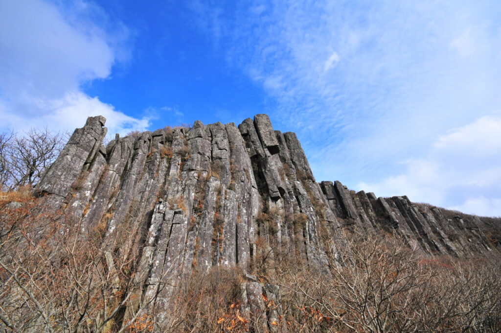
The most famous natural features are the columnar joints of Ipseokdae and Seoseokdae. Columnar joints form when hot volcanic material cools and contracts, splitting into large polygonal columns.
Ipseokdae consists of enormous rock pillars, some more than ten meters high, standing in a row. From a distance, they can resemble a defensive wall built by people, although they are entirely natural formations.
Seoseokdae is an extensive formation arranged like a huge stone folding screen. The preservation of such large columnar joints at high elevation is one of the area’s most important geological characteristics. Reaching these monumental rock formations after a long climb is one of the principal rewards of the hike.
• Ipseokdae: A formation of giant standing rock columns
• Seoseokdae: A broad wall-like columnar-joint formation
• Formed through volcanic activity and cooling
• Main destination of the upper hiking route
• Excellent for photography and geological observation
• Remain on designated trails to protect the formations
Why the Area Is a UNESCO Global Geopark
The Mudeungsan UNESCO Global Geopark extends across Gwangju, Damyang, and Hwasun. It includes Seoseokdae, Ipseokdae, Gwangseokdae, Jangbuljae, Jigong Neodeol, and Deoksan Neodeol among its major geological sites.
The present landscape developed through large-scale volcanic activity during the Cretaceous Period, followed by tens of millions of years of weathering and erosion. Cooling volcanic deposits formed the columnar joints, while broken rocks accumulated on the slopes to form block fields and rock streams.
For English-speaking travelers, the area is more than a scenic viewpoint. It functions like an outdoor geological museum where visitors can walk through evidence of volcanic activity and long-term landscape change.
• Geological landscape created by Cretaceous volcanic activity
• Includes the columnar joints of Seoseokdae and Ipseokdae
• Contains Jangbuljae, Deoksan Neodeol, and Jigong Neodeol
• Combines geology, ecology, history, and culture
• Offers hiking and geological education together
• A valuable place to observe Korea’s volcanic landscapes
Rock Fields Along the Trail
Large rocks covering the mountainsides are known in Korean as neodeolgeong or neodeol. In English, the terrain can be compared to a talus field, block field, or block stream.
Deoksan Neodeol and Jigong Neodeol are two representative areas. They are thought to have formed when water repeatedly froze and thawed inside cracks, separating blocks of rock that later accumulated across the slopes. The landscape contains rocks averaging approximately 0.5 to 1 meter in diameter, as well as much larger boulders.
Although the rock fields create distinctive photographs, leaving the trail and climbing across unstable boulders can result in ankle injuries or falls into gaps.
• Representative areas: Deoksan Neodeol and Jigong Neodeol
• Created through repeated freezing and thawing
• Angular rocks of many different sizes cover the slopes
• Useful for understanding geology and past climate
• Do not enter unmarked boulder fields
• Stay on designated paths for safety
Jeungsimsa and Korean Buddhist Culture
Starting from Jeungsimsa Entrance allows visitors to combine hiking with an introduction to Korean Buddhist culture. Jeungsimsa is a historic temple on the mountain’s lower slopes, and its grounds connect naturally with forest paths and hiking routes. Wonhyosa and Yaksa Temple are also located around the mountain.
Speak quietly when entering a temple hall and avoid taking close photographs of people praying. Visitors may be required to remove their shoes before entering certain buildings.
Travelers who do not want to complete a long hike can still visit Jeungsimsa and explore the surrounding lower forest paths.
• Combine a temple visit with a hike
• Remain quiet inside temple halls
• Be respectful when photographing visitors
• Shoes may need to be removed in some buildings
• Temple grounds and lower trails suit less active travelers
• Experience Korean Buddhist culture and nature together
Seasonal Hiking Conditions
Spring brings azaleas and wildflowers, summer produces dense green forests, autumn offers foliage and silver grass, and winter creates snow-covered scenery. Each season provides a different experience.
Korean summers are hot and humid, increasing physical strain even when the distance seems manageable. The monsoon season can bring heavy rain and thunderstorms, and upper routes should be avoided when the forecast is poor.
During winter, stone steps and rocks may freeze. Hiking to higher sections without traction devices can be dangerous.
• Spring: Azaleas, wildflowers, and changing temperatures
• Summer: High humidity and monsoon rainfall
• Autumn: Colorful leaves, silver grass, and larger crowds
• Winter: Snow scenery and increased ice hazards
• Carry sufficient water and electrolytes in summer
• Use microspikes or traction devices on icy winter routes
Recommended Hiking Equipment
Do not attempt the upper route in ordinary city-tour clothing. Wear hiking shoes or boots with reliable traction and bring a wind-resistant or waterproof jacket, sufficient water, and energy-rich snacks.
The large number of steps can place pressure on the knees, so trekking poles may be useful. A portable battery is also recommended because hikers may rely on their phones for navigation and emergency communication.
• Hiking shoes or boots with strong traction
• Windproof and waterproof outer layer
• Sufficient water, snacks, and electrolyte drinks
• Trekking poles or knee-support equipment
• Portable phone battery
• Microspikes, gloves, and a warm hat in winter
Water, Restrooms, and Trail Facilities
Restaurants and shops near Jeungsimsa Entrance sell bottled water and snacks. Commercial facilities become limited at higher elevations, so purchase everything necessary before beginning the climb.
Restrooms may be available at the visitor center and selected major points, but they are not continuously provided along every section. Use the restroom before starting and check facility locations on the trail map.
Lighting fires or cooking outside designated areas is restricted in Korean national parks. Trash bins may also be unavailable, so carry all waste back down.
• Buy water and snacks near the entrance
• Few commercial facilities are available in upper sections
• Use the restroom before beginning the hike
• Carry enough water for a longer route
• Cooking and open flames are restricted
• Carry all waste back with you
Safety and Emergency Information
In South Korea, call 119 for rescue, fire, or emergency medical assistance. Call 112 for the police. During an emergency, provide the number shown on the nearest trail marker or describe a nearby sign.
Photographing major trail signs can help explain your location if you become lost. Solo hikers should tell a hotel employee, friend, or family member about the planned route and expected return time.
Reaching the final viewpoint is less important than returning safely. Turn back immediately when weather conditions worsen or the hike takes longer than planned.
• Rescue, fire, and medical emergencies: 119
• Police: 112
• Photograph trail markers and location signs
• Share your planned route and return time
• Descend immediately if conditions deteriorate
• Prioritize a safe return over completing the route
Mudeungsan Watermelon and Local Gwangju Food
Mudeungsan watermelon is a traditional variety cultivated at higher elevations around the mountain. It is generally larger than an ordinary watermelon, with dark green skin and few or no visible stripes. Historically, it was presented to Korean kings as a valuable regional product.
The variety is produced from traditional seeds in a limited growing area, so availability is restricted. It is most likely to be found from late summer to early autumn.
After hiking, visitors can also try local barley rice near Jeungsimsa. This Korean meal combines rice with assorted vegetables, seasoned greens, and sauce, making it an accessible way for Western travelers to sample several Jeolla-style side dishes at once.
• A traditional watermelon cultivated near the mountain
• Known for its large size and dark green skin
• Historically presented as a royal regional specialty
• Availability depends on season and limited production
• Barley rice is recommended after the hike
• A convenient way to experience Jeolla vegetables and side dishes
Why Challenge-Seeking Hikers Should Visit
This mountain rewards endurance rather than technical rock-climbing ability. The route from Jeungsimsa to Seoseokdae provides substantial accumulated elevation, stone stairways, forest paths, rocky terrain, and exposed ridges while remaining accessible from a major Korean city.
The enormous pillars at Seoseokdae and Ipseokdae provide a distinctive reward at the end of the climb. The volcanic geology and regional atmosphere differ from Seoul’s Bukhansan and Jeju Island’s Hallasan, making the destination worthwhile even for hikers who have already visited Korea’s better-known mountains.
• Suitable for hikers who enjoy long uphill routes
• Includes stone stairs, rocky paths, and exposed ridges
• Reaching Seoseokdae provides a strong sense of achievement
• Offers a more regional experience than hiking near Seoul
• Physical preparation is more important than climbing technique
• Be willing to shorten the route according to weather and time
Essential Advice for First-Time Western Visitors
Travelers planning a serious hike should stay in Gwangju for at least one night. A same-day trip from Seoul may be technically possible, but combining long-distance transportation with a demanding hike creates an unnecessarily rushed schedule.
A more comfortable plan is to arrive in Gwangju the previous day, stay overnight, and travel from U-Square or a nearby hotel to Jeungsimsa Entrance early the next morning. After descending, visitors can eat near the entrance and return to central Gwangju to rest.
Speaking Korean is not essential on the main trails, but installing Naver Map or KakaoMap and saving destinations in Korean will make transportation significantly easier.
• Stay in Gwangju for at least one night
• Arrive the previous day and hike the next morning
• Avoid a rushed same-day round trip from Seoul
• Use Naver Map or KakaoMap
• Save Korean destination names and your hotel address
• Confirm that travel insurance covers recreational hiking
A Must-See Natural Destination in Gwangju
Mudeungsan connects the history, culture, and geology of Gwangju in one major natural attraction. Giant columnar joints rise above its rounded slopes, while traditional temples, rock fields, silver-grass ridges, and ancient volcanic landscapes appear throughout the park.
For English-speaking visitors who know little about Korea, the trip offers more than a day outdoors. Combining it with the city’s May 18 historical sites, the Asia Culture Center, and local cuisine reveals a side of the country that is difficult to experience through a Seoul-only itinerary.
• A representative national park of Gwangju
• Offers both challenging day hikes and shorter forest walks
• Features the unusual formations of Seoseokdae and Ipseokdae
• Can be combined with Gwangju’s democratic-history sites
• Receives fewer overseas tourists than major Seoul attractions
• Helps visitors understand Korea’s regional culture and natural landscape
Explore Korean Medical and Travel Information with Kosmedi
Kosmedi helps international travelers and patients conveniently find medical and tourism information in South Korea. Kosmedi provides hospital information checked by local Korean staff and helps users confirm whether English or other foreign-language interpretation services are actually available.
Users can immediately review hospital treatment events, prices, patient experiences, and detailed introductions. Discount coupons and special events available only through Kosmedi can also be accessed. Questions about hospital appointments, interpretation services, and visit schedules can be discussed through real-time message consultations.
Kosmedi does not provide hospital information alone. It also introduces popular Korean attractions, locally recommended destinations, restaurants, festivals, discounts, events, and regional travel information. International visitors can use Kosmedi to find both medical guidance and practical travel ideas for locations such as Gwangju and its surrounding natural attractions.
• Hospital information checked by local Korean staff
• Confirmation of actual foreign-language interpretation services
• Hospital treatment events, prices, reviews, and detailed introductions
• Kosmedi-exclusive discount coupons and special events
• Real-time consultation for hospital appointments and interpretation
• Information about Korean restaurants, festivals, discounts, and attractions
• Locally recommended destinations for international travelers

